OpenJUMP 1.4

Free OpenJUMP is an open source Geographic Information System (GIS)
1 
Rating
Your vote:
Latest version:
1.4.2 See all
Developer:
Screenshots
1 / 4
Awards (2)
Show all awards
Software Informer Editor Rating 5 Software Informer Virus Free award
Download
Free   13.3 MB

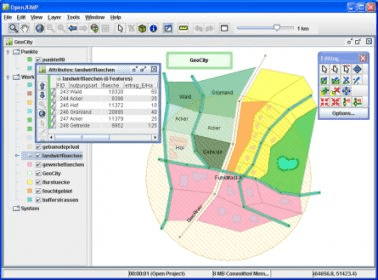
OpenJUMP is an open source Geographic Information System (GIS), it can read and write shapefiles and simple GML files. It has limited support for the display of images and good support for showing data retrieved from WFS and WMS web-services. So you can use it as GIS Data Viewer.OpenJUMP has limits in reading very large data files and has limited support for cartographic projections.

Editorial review:
Read a full review

Comments (1)

1
Rating
1 vote
5 stars
0
4 stars
0
3 stars
0
2 stars
0
1 stars
1
User

Your vote:

G
Giuseppe
We have reached to OpenJUMP version 1.10 with more features and tools, included a valid system to decode coordiante reference system of raster/vector files

Was it helpful?  yes(0) no(0) | Reply

Related software

JabRef
JabRef
Free
rating

Manage the list of references for your research papers in proper formatting.

gvSIG desktop
gvSIG desktop
Free
rating

Analyze, save, and process various geographic data.

GRASS GIS
GRASS GIS
Free
rating

Contains over 350 modules to render maps and images on monitor and paper.

Software Translator
Software Translator
rating

Software Translator will translate the interface of any program on the fly.

Christine-GIS
Christine-GIS
Free
rating

Combines visual geographic information with sophisticated computer applications.

Related suggestions